
Brooks County, Texas
- Profile
- Images
Location: Texas
Surnames/tags: Brooks_County, Texas us_history
| ... ... ... is a part of Texas history. Join: Texas Project Discuss: Texas |

- Texas Space Page
- The leader of this project is: Mary Richardson
Contents |
History/Timeline

|
| Brooks County courthouse, Falfurrias. |
FORMED
- 1848 Brooks County was formed from Webb and Starr County, Texas
- 9,200 b.c. to 6,000 b.c. Paleo Indian culture lived in the future Brooks County (lower Rio Grande River Valley) 11,000 years ago. [1] Artifacts are of the Native Americans. [1]
- 1500s (16th century), the Spaniards explored present day South Texas Counties in the Lower Rio Grande River Valley. The Spaniards condemned the territory uninhabitable even for livestock grazing. [1]
- 1600s - In the late 17th century when rumors of a French settlement reached the Spanish throne, Spaniards began considering establishing settlements in this area. The Spanish Monarchs had outlawed slavery of indigenous peoples in 1542. Spain's methodology was to convert the native Americans to Christianity (Catholicism).
- Note: it is possible so much agitation over control of the larger settlements of the rest of Texas overshadowed the records for Brooks area soon to be a County.
- 1767 - there were Spanish land grants in the Trans-Nueces region made.[1]
- 1800 efforts began to encourage colonists into the colony that would become Brooks county. [1]
- 1830 Los Olmos was established. It is the oldest settlement of Brooks county.. It was named after Ramon de la Garza's land grant, known as Los Olmos.[2]
- 1836-1848- In the time span of Texas Revolution (1836) until after the closing of the Mexican War, Brooks County was in an area that lay between the Rio Grande and Nueces River. [1]Texas had one agreement from Gen Santa Anna, but it is said the Mexican government did not accept Santa Anna's agreement... The USA (and Texas) and Mexico disagreed upon who owned the territory. [1]
- 1836-1848-Many recipients of grants moved back to Mexico. [1]Wandering vaqueros took up residence, giving trouble to the remaining settlers. these caused trouble to many of the original grantees, so that they fled to Mexico. Result: and much of the area was occupied only by wandering vaqueros. Gradually, with the cessation of hostilities, some families returned, but frequent droughts and lack of transportation discouraged permanent settlement.[1].
- 1846 this area was split to form San Patricio County was divided to form Nueces County,
- 1847-53 -King Ranch, located in portions of Brooks, Jim Wells, Kenedy, Kleberg, Nueces, and Willacy Counties.. Acreage- 825,000 Acres Primary use of the Ranches: Cow-calf, feed yard, farming, horses, oil and gas, wild game hunting, birding. This is the most successful ranch of Texas with the most stories.. Captain Richard King, stow-away on a steamship and pilot during the Mexican American war and later the Civil War. He made a fortune on his steamship business. When he founded the ranch, he knew almost nothing about cattle ranching. He made smart decisions on buying land with the only fresh water. King was also able to coax a whole Mexican town of vaqueros to move to his ranch in Texas and thus work for him..The King Ranch, Inc.—it was incorporated in 1934—has diversified interests ranging from agribusiness to oil and gas, and it is co-owned by Captain King’s heirs and other stockholders.[3]
- 1853 Richard King purchased the Santa Gertrudis grant in Kleberg County from the heirs of the original Spanish grantees and started the King Ranch. [4]
- 1848 The area was divided again to form Cameron County, Webb, and Starr counties.
- 1848 Brooks County was formed from Webb and Starr County, Texas
- 1911, after several years of effort, Lasater, with the help of State Representative John Abijah Brooks, succeeded in having Brooks County separated from Starr County, with Falfurrias as the county seat
- Post 1865- New settlers were ranchers, and many of them married into the prominent families of the time, acquiring the social status of the region.
- 1895 - The founding of Falfurrias is thanks to the work of a pioneer of Rio Grande Valley, Edward Cunningham Lasater Falfurrias [5]
- 1895 Lasater began his ranch in what was then the north part of Starr County. He bought/ acquired extensive acreage (over 350,000 acres) and bought over 7,000 cows from the Kenedy Pasture Company. In addition to the Butter, cream products, Lasater also was a breeder of Jersey cattle in the USA. It became one of the largest ranches. [5]
- 1897 Jones Family Ranches location in Brooks, Jim Hogg, and Starr Counties.. total acreage 380,000 ACRES, used for cattle, OIL and GAS, WILD GAME Hunting... When William Whitby Jones said he wanted to go into ranching, his dad, Captain A.C. Jones who owned a bank and mercantile store in Beeville was displeased!! Worse than that it seemed to be in a bandit infested and isolated place called South Texas. The parent had given the son a good education at Roanoke College in Virginia and business school. William Whitby bought 6 acres in Jim Hogg County (part of Las Animas Land grant. Gradually Jones with his wife added 373,000 acres. Today his grandchildren and great grandchildren own the ranches.[6]
- 1898, a post office opened in the community. A local newspaper began publication in 1906
- 1904 --When the San Antonio and Aransas Pass Railway went through south from Alice to his ranch,that helped get merchandise and settlers to the area. Thus Lasater founded Falfurrias, then he divided a part of the ranch land to sell portions to other farmers. [5]
- 1906 E. R. Rachal planted the first citrus trees, followed by years of freezes,
- 1909 -Lasater began the grazing ranch and raising of Jersey cows and established a creamery. It takes good grass to produce delicious sweet cream butter. This butter, and the other products gave the town the name we see in grocery stores other products. [5]
- 2016 -It seems that today that butter is no longer made from milk produced in Falfurrias. [7] This article describes how its author investigated the Falfurrias name on the carton. The author of above article found the grandson who told him how hard it is to maintain good quality and still be commercially competitive.. Thus eventually another company bought out the business. Read the article. Falfurrias</ref> Now the Dairy Farmers of America, which has a huge plant in Winnsboro, owns the family-owned butter company.!!
- 1910- Early 1910 some other ranchers from western Brooks County began trying to get a county formed free from Lasater's influence.
- 1911 -The state granted a petition by local residents to form a new county, Brooks, with Falfurrias as its county seat.[5]
- 1911 Lasater was able to get Brooks separated from Starr County due to help from John Abijah Brooks.[8]
- Falfurrias was named the county seat.
- 1913 Jim Hogg County was formed from 990 square miles of Brooks County, and Brooks County assumed its present dimensions.
- 1900 to 1940 Brooks County was still essentially a ranching economy.
- 1920's - Irrigation methods introduced to the area brought in truck farming and the citrus fruit industry. The city became a primary trade and shipping center for the surrounding region. The area received another economic boost in the 1930s and 1940s when extensive oil and gas reserves were discovered around Falfurrias.
- 1920's and 1930's Many of the cattle were dairy cattle. Falfurrias is known for its dairy products and BUTTER.
- 1930 - 1980 Brooks County is counted as 7th of United States counties for high percentage of residents of Hispanic origin.
- Newcomers were ranchers, and many of them married into the most prominent families and adopted the existing social customs.
- Lasater, a Republican and Manuel Guerra had several run-ins or encounters, as they each tried to maintain control of this land.
East Family Ranches, in counties: Brooks, Cameron, Hildago, Jim Hogg, Kenedy, Kleberg, Starr, And Willacy counties. (340,000 Acres) used for Cattle, oil, gas, no known date of founding.
- This ranching family will not talk to the press. According to the 1957 book, "The King Ranch" by Tom Lea: Tom T East a rancher married Alice Kleberg, granddaughter of Richard King and the King Ranch in 1915. The newlyweds went to live on Tom East's San Antonio Viejo Ranch located 75 miles from the King Ranch. The Easts suffered financial troubles and sold their 77,000 acres . After this the first oil well was found on their ranch San Antonio Viejo.).. Upon Alice Kleberg's death, her estate was transferred back to the East family.
- Robert and Evelyn East, widow of his brother own the East Family Ranches. Robert owns the San Antonio Viejo, Casa Verde and San Pablo while while Evelyn East owns the Santa Fe.[9]
- Bass Family Ranches, Location in Aranasas, Atascosa, Brooks, Hidalgo, Johnson, Kenedy, Kleberg, Parker, Red River and Tarrant counties (ACREAGE: 150,000 Acres)
- The Basses are similar to the Easts. The family is very tightlipped. Neither the family or employees will confirm location, acreage. According to what we can find, there are 3 Texas ranches.
- 1) Lee Bass owns El Coyote (S of Falfurrias )
- 2) Ed owns the Wainscot (SW of Fort Worth)
- 3) the Bass family owns the San Jose cattle company on the Gulf Coast as well as additional acreage scattered around Texas..
- 4) Winfield Scott founded Winscott, founded by Winfield Scott (Fort Worth millionaire)
- 5) San Jose Ranch is located on San Jose Island (north of South Padre. Cattle would have to swim or be transported by barge to and from the mainland. (The Island has an airstrip, but is used for people).[10]
Formed From
- 1911, after several years of effort, Lasater, with the help of State Representative John Abijah Brooks, succeeded in having Brooks County separated from Starr County, with Falfurrias as the county seat.[Texas Handbook, Books County]
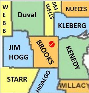
Adjacent counties

|
| Adjacent counties. |
Land Grants
Twenty-five land grants
- 1747 land grants in the Trans-Nueces region were made by the Spanish Monarchs.
- Nov 8 1797 - San Salvador del Tule grant to Juan José Ballíon November 8, 1797.
- 1827- grant to Luciano Chapa ( El Encino en el Poso)
- 1830 grant to Ramón de la Garza ( El Paisano/Los Olmos)
Government Office
Falfurrias, the county seat, was established in 1895 and named after Lasater's ranch, La Mota de Falfurrias.
Brooks County has only had one courthouse.
|
|
| Brooks County courthouse, Falfurrias. |
1911-1st Brooks County Courthouse, - "This building was the first and only courthouse built for Brooks County.
- June 2006 annex was opened and the 1914 court house closed to have renovations done. " - Terry Jeanson, [11]
- Brooks' courthouse is of the Classical Revival", a design of Beaux Arts style used in some Revival architecture which was renovated in 1914. When the courthouse was built, two (2) cornerstones with the names of county officials, architect, contractor and holds two copies of the town's local paper, El Burro" and some U.S and Mexican coins.
[12]The Masonic cornerstone received an anointment of the “Corn of Nourishment”, the “Wine of Refreshment”, and the “Oil of Joy”, courtesy of the local Masonic Lodge, as incentives toward the welfare and prosperity of Brooks County. [12]
Geography
- Brooks County, Texas is a forbidding county. Its land is known for: tangled mesquite, sand pits, rattlesnakes and thick cacti.
- Spaniards nicknamed this region Wild Horse Desert.
- Location - Rio Grande Plain region located S of Corpus Christi on U. S. Highway 281.
- Adjacent counties- north by Duval and Jim Wells counties, east by Kleberg and Kenedy counties, south by Hidalgo and Starr counties, west by Jim Hogg County.
- Latitute/Longitude: 27°03' north latitude and 98°14' west longitude.
- County Seat -Falfurrias, the county's largest town, county seat, is in NE Brooks County at the junction of U.S. Hwy 281, State hwy 285, and Farm roads 2191 and 1418.
- Other communities include Encino, Flowella, and Rachal.
- Size: - 942 sq mi of brushy mesquite land.
- Elevation - 100-400 feet
- Soil - surface -loamy at the surface and clayey beneath level to undulating, poorly drained soils with isolated dunes in the NE corner
- Vegetation/trees-- live oak, mesquite, brush weeds cacti, grasses.
- Farmland - 1-10% considered prime
- Mineral - caliche, gypsum, salt domes, oil, and gas.
- Temperatures range from 44° F to 69° in January and 73° to 97° in July.
- Rainfall - twenty-five inches
- Growing Season averages 310 days.
Roads/Highways
- U.S. Highway 281
- I- 69C -will follow US. 281 mostly New
- Texas State Highway 285
- Texas Farm to Market Road 755
Demographics
- Encino Division of the King Ranch (3/4 of the division) is in the eastern part of county
The census of 2000 reflected there were 7,976 people giving a density of 8 people per sq mi. Racial breakdown was 75.84% White, 0.19% Black or African American, 0.46% Native American, 0.09% Asian, 0.08% Pacific Islander, 21.58% from other races, and 91.57% of the population were Hispanic .
The median income for a family in the county of $22,473. Males had a median income of $23,051 versus $16,103 for females. The per capita income for the county was $10,234. About 36.90% of families and 40.20% of the population were below the poverty line, including 51.70% of those under age 18 and 30.40% of those age 65 or over.
Politics
Although the majority of Texas is Republican currently, Brooks County has never voted for a Republican Presidential candidate since its creation in 1911. This makes Brooks county a stronghold for Democracy.
Even in 2004 In the 2004 presidential election, the county gave 1,820 votes to Democratic candidate John Kerry to 844 for Republican George W. Bush.
In 2012, 78.5% of the county's voters chose President Obama.
Cities, Communities
- Airport Road Addition, Texas
- Cantu Addition, Texas
- Encino
- Falfurrias (county seat)
- Flowella
- Rachal
Things to do/see
- Texas Tropical Trail is in Brooks County.
- Hunting
- Fiesta Ranchera in May
- Watermelon Roundup- June
- Mexican Village Celebration, June
- Fourth of July Rodeo.
Schools

|
Cemeteries

|
- No Cemetery Categories have been created for Brooks County as of 2018
- FindaGrave cemeteries of Brooks County, Texas
- List of Brooks County Cemeteries
- Brooks County Cemeteries by Gloria Mayfield
National and State Historical Markers
- Historical Marker — 5047000522, Brooks County Courthouse — Brooks County Courthouse (1914), National Register Listing — 2012000193
- Historical Marker — 5047000523, Brooks County's Catholic Heritage — Brooks County
- Historical Marker — 5047000524, Don Pedro Jaramillo (1829-1907) — Brooks County
- Historical Marker — 5047001248, El Encino del Poso (The Oak in the Hole) — Brooks County
- Historical Marker — 5047001414, El Lucero — Brooks County
- Cemetery — 7047000905, Falfurrias — Brooks County
- Historical Marker — 5047001561, Falfurrias to Encino Road — Brooks County
- Historical Marker — 5047012799, First United Methodist Church of Falfurrias — Brooks County
- Historical Marker — 5047001888, Garcia — Brooks County
- Cemetery — 7047002005, Garza Zamora Family Cemetery — Brooks County
- Cemetery — 7047001405, Heritage Museum — Brooks County
- Museum Information — 4200000144, Huerta — Brooks County
- Cemetery — 7047002205, James Abijah Brooks — Brooks County
- Historical Marker — 5047002712, Longoria — Brooks County
- Cemetery — 7047000505, Old Town — Brooks County
- Cemetery — 7047001005, Pedro Jaramillo — Brooks County
- Cemetery — 7047001505, Perez — Brooks County
- Cemetery — 7047000205
- Cemetery — 7047001205
- Cemetery — 7047001605, Rancho Nuevo — Brooks County
- Cemetery — 7047000405, Site of Los Olmos — Brooks County
- Historical Marker — 5047004823, Town of Flowella — Brooks County
- Historical Marker — 5047001925, Unnamed — Brooks County
- Cemetery — 7047001905
- Cemetery — 7047002105, Vallerreno — Brooks County
- Cemetery — 7047000605, Vivian and Juanita Perez De Luna Cemetery — Brooks County
- Cemetery — 7047000105, unknown (N Falfurrias) — Brooks County
- Cemetery — 7047001105, unknown (Palobla Creek) — Brooks County
- Cemetery — 7047001705, unknown (S Encino) — Brooks County
- Cemetery — 7047000805, unknown (SE of Flowella) — Brooks County
- Cemetery — 7047001305, unknown (SW Encino) — Brooks County
- Cemetery — 7047000705, unknown (Tacubaya) — Brooks County
- Cemetery — 7047000305, unknown grave (N Lucero Cem) — Brooks County
- Cemetery — 7047001805

|
| Brooks co. courthouse, 1940 postcard. |
Sources
- ↑ 1.0 1.1 1.2 1.3 1.4 1.5 1.6 1.7 1.8 https://tshaonline.org/handbook/online/articles/hcb16
- ↑ Paisano (Los Olmos)
- ↑ http://www.texasmonthly.com/articles/the-biggest-ranches/
- ↑
- ↑ 5.0 5.1 5.2 5.3 5.4 5.5 https://en.wikipedia.org/wiki/Falfurrias,_Texas
- ↑ http://www.texasmonthly.com/articles/the-biggest-ranches/
- ↑ http://www.dallasobserver.com/restaurants/whats-the-truth-behind-a-label-a-story-of-texas-butter-nostalgia-7027326
- ↑ https://tshaonline.org/handbook/online/articles/fbrdv
- ↑ http://www.texasmonthly.com/articles/the-biggest-ranches/
- ↑ http://www.texasmonthly.com/articles/the-biggest-ranches/
- ↑ http://www.texasescapes.com/TOWNS/Falfurria_Texas/Brooks-County-Courthouse-Falfurrias-Texas.htm
- ↑ 12.0 12.1 Historic Sites
- http://www.themonitor.com/news/local/in-poorest-county-in-texas-at-center-of-us-border/article_f0b3bfc2-25a0-11e4-8644-0017a43b2370.html
- http://latinousa.org/2014/01/03/brooks-county-m-oribe/
- https://tshaonline.org/handbook/online/articles/hcb16
- http://texastropicaltrail.com/plan-your-adventure/historic-sites-and-cities/sites/brooks-county-courthouse
- "State & County QuickFacts"
- Saslow, Eli. "Going it alone". www.washingtonpost.com. The Washington Post. Retrieved 10 August 2014.
- Falfurrias on Texas Escapes Online Magazine
- Brooks County, Texas
- https://en.wikipedia.org/wiki/Falfurrias%2C_Texas


- Login to edit this profile and add images.
- Private Messages: Contact the Profile Managers privately: Mary Richardson and Paula J. (Best when privacy is an issue.)
- Public Comments: Login to post. (Best for messages specifically directed to those editing this profile. Limit 20 per day.)